Throughout the Proxima mission onboard the ISS from November 2016 to June 2017, French astronaut Thomas Pesquet took many superb photographs of Earth, which he posted on social media. Here, Honolulu’s Daniel K. Inouye International Airport.
On 5th February, Thomas Pesquet posted this view of O'ahu Island, with the following comment: "First US airport for my collection: Honolulu! How about now I have to fly into all of these after I’m back on earth? Challenge accepted!".
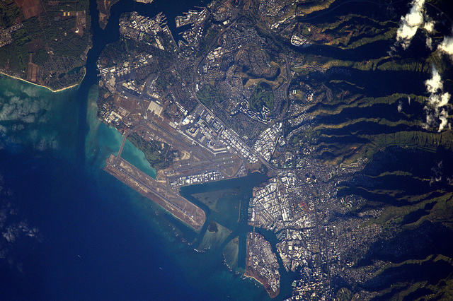
The image was taken from the ISS on 16th January, using a Nikon D4 equipped with a 1,150mm telephoto lens. North is at 1 o’clock on the photograph. We are above Honolulu airport on the O'ahu Island of the Hawaiian Archipelago.
We know that, before becoming an astronaut, Thomas Pesquet was a pilot. As such, he particularly likes airports and other airstrips that he can photograph at his leisure from the ISS, as illustrated by this picture.
We are in Hawaii, an archipelago of the North Pacific Ocean, named after its largest island (the island of Hawaii is the southernmost of the archipelago). It is also a state of the United States of America. Also known as the Sandwich Islands, these islands number 137 (with the atolls and many islands and seamounts). The complex stretches 2,400km between the northernmost island (Kure atoll close to Midway) and the southernmost island (Island of Hawaii).
These islands are for the most part the emerging part of an incredible chain of submarine mountains formed by the volcanic activity of a hot spot. What is a hot spot? Imagine a torch beneath the earth and oceanic crusts, which pierces the mantle. With help from continental drift, the torch generates a chain of volcanoes often aligned ...
O'ahu Island is the third largest island in this archipelago, with an area of 1,545km2. It is also the most populated, with about 1 million inhabitants, or nearly 75% of the population of the whole state. The photograph is centered on the airport of Honolulu, the capital ciy located on the island’s south coast.
If you look closely, you can even see in the upper left of the picture, part of the famous port of Pearl Harbor, which was attacked by Japan on 7th December 1941, leading to the United States’ entry into World War II. This naval base at Pearl Harbor is home to the U.S. Pacific Fleet Headquarters. The port and base are located around a roadstead in the centre of which is the island of Ford whose southern tip can be seen. The entrance to this harbour is through a very narrow channel also clearly visible on the photo.
Let's go back to the airport. It exists since 1927, has 4 paved land runways and 2 offshore runways for seaplanes! All are clearly visible on the photo. The two main paved runways are parallel and oriented east-west with lengths of about 3,700m. The two offshore runways (which form a triangle with an additional runway) are shorter (approximately 1,000 and 1,500m) and are located to the southeast of the airport. Clearly, this part of the lagoon has been dredged to build the paved and offshore runways. The rubble helped to reclaim land from the ocean.
The rest of the photograph shows that the urban and industrial fabric of the city of Honolulu is concentrated at the foot of moutainous terrain. On the right side of the photograph, the foothills of the volcanic massif are on the island: the Ko'olau volcano and its bare slopes with deep ravines and spur ridges. Runoff must be particularly effective here ...
Find the image on Google Maps!
https://www.google.fr/maps/@21.315862,-157.9326894,6831m/data=!3m1!1e3?hl=fr&authuser=0
*Gilles Dawidowicz is a geographer, president of the Planetology Commission of the French astronomical Society.