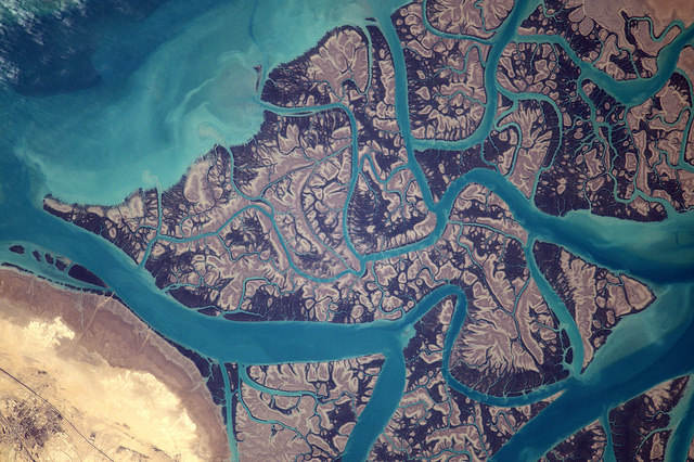
Throughout the Proxima mission onboard the ISS from November 2016 to June 2017, French astronaut Thomas Pesquet took many superb photographs of Earth, which he posted on social media. Here, Clarence Strait, in Iran.
On 24th February 2017, Thomas Pesquet posted this view of Clarence Strait, with the following comment: "Psychedelic shapes on the east coast of the Persian Gulf".
The image was taken from the ISS on 31st December, using a Nikon D4 equipped with a 1,150mm telephoto lens. North is at 2 o'clock. We are above Clarence Strait, close to Qeshm Island (Hormozgan Province) in the Strait of Hormuz on the southern Iranian coast.
The Strait of Clarence (not to be confused with those of the same name in Australia or the United States), also called the Khuran Strait, is a small strait separating the Iranian mainland from Qeshm Island, in the Persian Gulf. We are about 50km southwest of the city port of Bandar Abbas (Iran) and about 150km north of Dubai (United Arab Emirates), but on the other side of the Strait of Hormuz. This narrow strait is two to nine kilometres wide and about 170km long.
This magnificent photograph by Thomas Pesquet is centered on a mangrove area and a small part of the Hara forest, named after a small tree that is widespread there, the Avicennia marina (known locally as Hara). This very fragile wetland covers more than 1,000km2 and has been listed since 1975 on the Ramsar Convention list. Because, like all the mangroves in the world, this one is very rich and abounds in exceptional fauna and flora. There are birds and waders (e.g. herons, flamingos, pelicans, eagles, spoonbills ...), but also fish, shellfish, reptiles of all kinds (rare lizards, marine turtles, aquatic snakes ...), and even ... dugongs!
As for Qeshm Island (part of which is a UNESCO Biosphere Reserve) and a very small part of which is visible at the bottom left of the image, it is oblong in shape. It is about 110km long and has an area of 1,295km2. It is the largest island of Iran and the Persian Gulf. The town of Qeshm (20,000 inhabitants) is located on the northeastern tip, while the city port of Basaidu is located at the southwest tip. Dates and melons are cultivated on this rocky soil when irrigation is possible. Fishing, livestock, oil, gas and tourism are the main economic activities.
Find the image on Google Maps!
https://www.google.fr/maps/@26.8352097,55.6836271,40321m/data=!3m1!1e3?hl=fr&authuser=2
*Gilles Dawidowicz is a geographer, president of the Planetology Commission of the French astronomical Society.