Throughout the Proxima mission onboard the ISS from November 2016 to June 2017, French astronaut Thomas Pesquet took many superb photographs of Earth, which he posted on social media. Here, the Danube delta, in Romania.
On 23rd February 2017, Thomas Pesquet posted this view of Romania, with the following comment: "Oddly bent river somewhere in Romania".
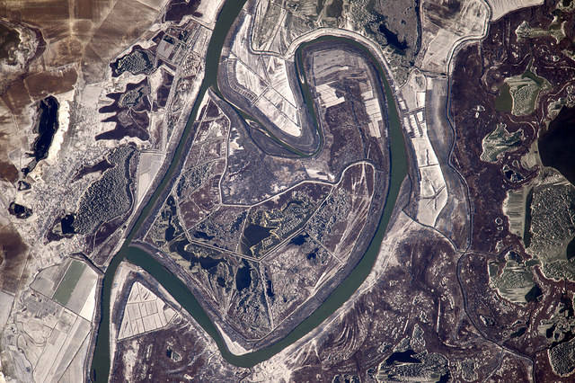
The image was taken from the ISS on 31st December, using a Nikon D4 equipped with a 1,150mm telephoto lens. North is at 3 o'clock. We are above a meander of the Danube delta, in Romania. The Danube is the second largest river in Europe (after the Russian Volga) by its length, which exceeds 3,000km. It takes its source in the Black Forest (Germany) and flows into the Black Sea, some 30km northeast of where we are.
The delta covers an area of more than 3,000km2. To the north of the delta, the Chilia arm is a defluent (the northernmost of the three main branches of the delta), which forms a secondary delta at the Black Sea. This northern border also marks the border between Romania and Ukraine. To the south, it is the St. George arm which delimits the southern part of the delta. In the centre, the Sulina arm.
Coming back to the photo, overnight temperatures have been significantly negative for several weeks, and the landscape is slightly frozen. The photograph is centered on an astonishingly shaped loop located in the St. George arm (Dunaszentgyörgy). Contrary to what Thomas Pesquet thinks, this meander is not a paleomeander, since it’s very active and current. It is in fact a natural, inherited loop, testifying to the dynamism of the river, which has been turned into a fish farm. The zoom reveals canals, water basins and aisles in the center of the loop and in the surrounding plots.
But geometry surprises the eye of the observer (and attracted that of our astronaut), because generally the loops of the meanders are simple. In this case, the loop is intersected, which ultimately divides the course into two channels, a main channel and a secondary channel. This overlap, about 100m wide, has been dug through the delta. It is therefore artificial and makes it possible to navigate the arm of St George from the Black Sea, for nearly 64km.
In the lower right of the image, traces of paleomeanders and paleochannels, which betray the old traces of the arms of the river, can be seen. And on the right, lakes and other small pools. Finally on the left, the village of Mahmudia with its small port, the town of Murighiol and its small frozen lake and the hamlet Uzlina (at the bottom of the image, in the center).
The entire delta region is an exceptional biosphere reserve and is home to hundreds of plant varieties, nearly 1,000 species of insects, more than 300 species of birds and 45 species of freshwater fish in its lakes and marshes. It is a naturalist’s paradise, even though poachers are threatening the survival of certain rare species: white pelicans, curly pelicans, white spoonbills, pygmy cormorants, white-tailed eagles, rare osprey, ruddy shelducks, and white-headed ducks that have almost completely disappeared in the rest of Europe. Other animals also live here like newts, otters, but also the mysterious viverrin dog...
Find the image on Google Maps!
https://www.google.fr/maps/@45.0804383,29.133789,15567m/data=!3m1!1e3?hl=fr&authuser=0
*Gilles Dawidowicz is a geographer, president of the Planetology Commission of the French astronomical Society.