Throughout the Proxima mission onboard the ISS from November 2016 to June 2017, French astronaut Thomas Pesquet took many superb photographs of Earth, which he posted on social media. Here, the Jebel Arkanu, in Libya.
On 25th February 2017, Thomas Pesquet posted this view of the incredible massif in southeast Libya, Jebel Arkanu, with the following comment: "Africa is full of treasures for the eyes. A beautiful rock formation in the desert of Chad".
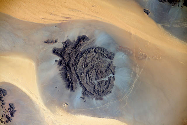
The image was taken from the ISS on 5th January, using a Nikon D4 equipped with a 240mm telephoto lens. North is at 8 o'clock. We are above an astonishing Libyan mountain: the Jebel Arkanu.
We could be in a Star Wars episode, on a desert planet in a distant galaxy. We are actually in the extreme southeast of Libya (Al-Koufrah district), about 300km southeast of the town of El Tag, just a few kilometers west of the border (vertical) with Egypt and a few kilometers north-west of the border (at right angles) with Sudan. In the middle of the Sahara desert, the landscape is worthy of Ares Vallis, the famous paleo-valley of the Martian river!
Thomas Pesquet has discovered an interesting and unique geological curiosity: the Jebel Arkanu mountain massif. While the desert surroundings are relatively depressed, this oval mountain (28km x 18km) soars above the landscape in an unprecedented way, culminating at 1,435m above sea level, overlooking the sandy Gilf Kebir plateau of at least 500m.
It is a very old formation composed of a granite intrusion on the one hand, and a valley-oasis on the other. The whole has a spiral aspect, forming almost concentric rings.
The vegetation is made up of bushes, grasses and rare trees. And yet, the Jebel Arkanu is a pasture place: each year, the nomads drive their herds, block the entrance of the channel with stones, and return three months later to catch the cattle.
This region is known to be one of the most arid in the world (less than 1mm of water per year on average), but also to shelter magnificent petroglyphs, testifying to a much more humid and rich past with giraffes and other animals now absent from this part of the world.
Find the image on Google Maps!
https://www.google.fr/maps/@22.2955698,24.6857144,38583m/data=!3m1!1e3?hl=fr&authuser=0
*Gilles Dawidowicz is a geographer, president of the Planetology Commission of the French astronomical Society.