Throughout the Proxima mission onboard the ISS from November 2016 to June 2017, French astronaut Thomas Pesquet took many superb photographs of Earth, which he posted on social media. Here, the Brahmaputra, in India.
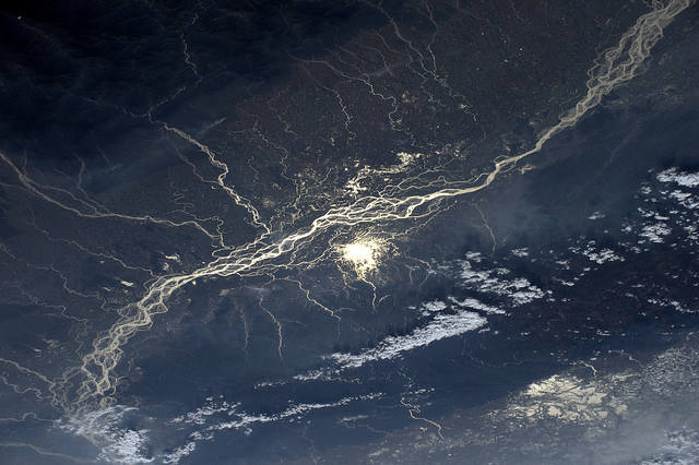
On 26th January 2017, Thomas Pesquet posted this view of the meandering Brahmaputra, with the following comment: "The sun is reflected on the ramifications of the Brahmaputra River in India."
The image was taken from the ISS on 30th December, using a Nikon D4 and a 140mm telephoto lens. North is around 11 p.m.
This is a special region of India, at the eastern end of the country. It is a portion of Indian territory wedged between Bhutan and China (Tibet in fact) to the north, Burma to the east and south and Bangladesh to the west. It is not strictly speaking a panhandle (a corridor formed by a long, narrow geographical extension) but a kind of enclave narrowed to the extreme in its western part at the level of Nepal.
This region is administratively composed of the Meghalaya, the "Abode of the Clouds" (a state whose capital is Shillong), Assam (capital, Dispur), Nagaland (capital, Kohima), Manipur (capital, Imphal), the Mizoram (capital, Aizawl) and the Tripura (capital, Agartala).
The photograph is superb, as the landscape looks incredibly wild here (it is not on the ground). But the Brahmaputra picks its own path, and its extremely braided aspect testifies to this.
A zoom on the image makes it possible to observe in detail the course of the river, its meanders, its innumerable islands and equally magnificent tributaries. The Brahmaputra picks its own way. We do not impose it. It is 2,900km long and takes its source in the Tibetan Himalayas at an altitude of more than 5,500m, in a glacial environment. It takes its time to flow and dissipate its energy laterally. Here, the slope must be low, which explains these multiple plots.
The river crosses three different countries and changes its name according to the country it passes through: Yarlung Tsangpo in Tibet, Brahmaputra in India and Jamuna in Bangladesh, the furthest downstream. Once the high mountains have passed, its course becomes tropical, making it a rich and fertile environment, both from a biodiversity point of view and from an agricultural point of view.
Its irregular flow regime generates violent floods in the monsoon (high water from June to October) and a severe low (from January to March during the dry season). Islands and islets appear and disappear in the course of seasonal episodes...
But let's zoom in on the image again. If we look closely, there are some fires whose plumes are clearly visible. They could be foresters who continue to chop down the trees: more than 70% of the forest that originally covered the downstream region of the river has disappeared. What is left is being destroyed at a rate of 10% per year, and currently only 4% of the area is protected.
There are also some small towns along the river, although the image and the solar illumination are not conducive to revealing their presence, for it must be confessed, they are very scattered. As for the solar illumination, it gives the impression that the catchment area of the Brahmaputra has more tributaries on the right bank (top of the photograph) than on the left bank. This is not only an impression: the tributaries of the right bank are more numerous and more important. They also come from the high summits of Nepal and Tibet. From this point of view, there is an imbalance with the left bank whose watershed is less efficient.
Brahmaputra is also a natural biogeographic boundary for many species, some of which are endemic to each shore. Finally, this region of the river harbors the largest population of elephants in India, the world's largest population of unicorn rhinoceros from India, tigers, and buffaloes from India.
Find the image on Google Maps!
https://www.google.fr/maps/@26.585945,93.0594919,159031m/data=!3m1!1e3?hl=fr&authuser=0
*Gilles Dawidowicz is a geographer, president of the Planetology Commission of the French astronomical Society.