Throughout the Proxima mission onboard the ISS from November 2016 to May 2017, French astronaut Thomas Pesquet took many superb photographs of Earth, which he posted on social media. Here, Mont Saint-Michel, in France.
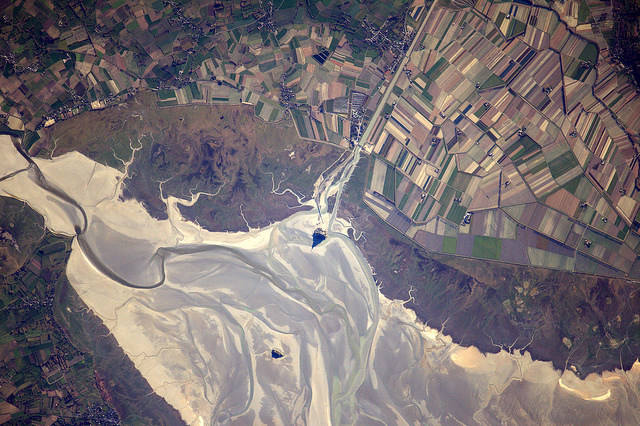
On 19th January 2017, the 63rd day of the Proxima mission, Thomas Pesquet posted this view of Mont Saint-Michel in Normandy with the following comment: “The Mont-Saint-Michel is famous for only being accessible at low tide. We were lucky to fly over at the right time to capture the beauty of its shadow, sketching its silhouette in the sand “.
The image was taken on 28th December, using a Nikon D4 equipped with a 1,150mm telephoto lens. Perfectly centered in the photo, the old rocky island appears in all its splendour, in the characteristic coastal mudflats of the area. Viewed from an altitude of 400km, its shadow takes the form of a delta wing pointing to the North! The tide is out.
These mudflats are characterized by a striking dichotomy: upstream, the schorre and downstream, the slikke. The dark schorre (or palud, in Breton), is the upper part of the mudflat. It is covered only at high tides. It is characterized by a halophilous vegetation (which loves and flourishes in salty environments). The low schorre is covered with each tide (except during the dead waters) and is colonized by plants such as soda and maritime aster. The medium schorre presents a vegetation of bushy appearance, due to the obione. As for the high schorre, it is composed of salicornes, spartines, sea lavender or sage.
One can clear see the slikke corresponding to the part of the mudflat that is covered with each tide. It is mainly composed of soft vases, with a smooth appearance and without vegetation. It is home to a significant amount of bacteria. It is also home to a variety of fauna including bivalves popular with locals (clams, shells...), green crabs and fish (mule, plaice, bar).
Pesquet’s image also shows very well the hair and the tresses left by the runoff during the withdrawal of the tide. On the left, the channel of the Sée and Sélune rivers is particularly visible. At the top of the image, in the axis of the Mont, the bed of the Couesnon river, which also flows into the bay, can be seen extending straight out from the shore.
Finally, in an extension of the same axis, is the granite island Tombelaine, whose area is 7.4 acres. The tirangular shadow of the Mont Saint-Michel seems to point towards it.
Find the image on Google Maps!
https://www.google.fr/maps/@48.6537208,-1.5275435,8454m/data=!3m1!1e3?hl=fr&authuser=2
*Gilles Dawidowicz is a geographer, president of the Planetology Commission of the French astronomical Society.