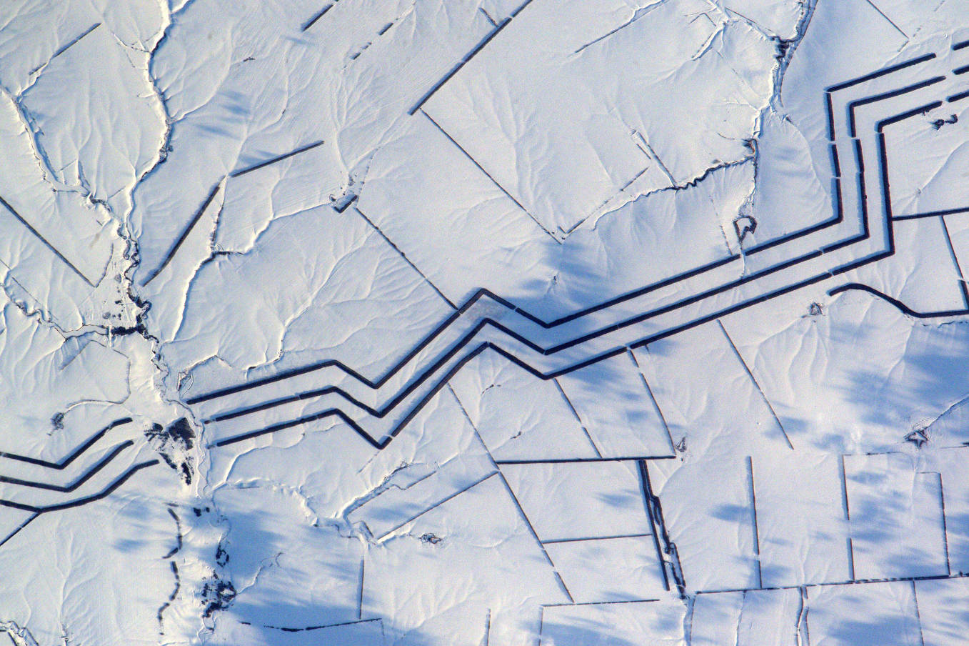
Throughout the Proxima mission onboard the ISS, French astronaut Thomas Pesquet took many superb photographs of Earth, which he posted on social media. Here, rows of trees and snowy fields, in Russia.
On 16th March 2017, Thomas Pesquet posted this view of a snow-covered Russian landscape, with the following comment: "Minimalist snow art in Russia. I cannot explain these km-long parallel lines".
The image was taken from the ISS on 16th February, using a Nikon D4 equipped with a 1,150 mm telephoto lens. North is at 7 o'clock. We are above Western Russia, between Ukraine and Kazakhstan in the Volga Federal District, 200km north of Volgograd and 10km south of the village of Shchelokovka.
You have to go back in time to understand this strange and unusual landscape. Russia has always been struck by terrible famines. Already under the imperial era, world economic crises, the tyranny of the ruling class, a feudal Russian society in the process of industrialization, a strong birth-rate and an economic strategy of the empire supporting exports did not help. The people of the countryside were regularly starved, as in 1891-1892, when 2 million people died along the Volga, in the Urals and even in the Black Sea. When winters and dry summers followed one another, harvests were not diverted to the hungry, but reserved for exports, and the number of victims soared.
The Bolsheviks did no better. The Russian famine of 1917-1922 claimed nearly 1.5 million victims, especially in the Volga-Urals region. The Soviet Union was created in 1922, and a new famine occurred in 1932-33, with about 8 million deaths occurring throughout the Union. This was partly organized by the communist leadership, like that which affects the Ukraine: it is extermination by hunger. During the war (from 1941 to 1945), the Nazi regime reserved for the territories of Ukraine and White Russia a policy of famine planned by the Reich Minister of Food, Herbert Back. The defeat of Nazi Germany put an end to this diabolical plan. But before that, the siege of Leningrad by the German armies, from 8th September 1941 to 27th January 1944, claimed about 1 million victims (out of the 2.9 million inhabitants of the city), 97% of whom died of hunger .
At the end of World War II, the Soviet Union was on its knees and the Kremlin's master, Joseph Stalin, had to work in all fields of industry and agriculture in order to quickly rectify the situation. The population, martyred by decades of tyranny, was still regularly struck by famines. That of Gagauzia in 1946-1947 killed more than one-third of the population of each village (Gagauzia is an autonomous district of the South of the Republic of Moldova, near the border with Ukraine).
Stalin set up a large-scale macro-engineering project, the "Great Plan for the Transformation of Nature", with the aim of improving agriculture in general, combating soil erosion, developing agricultural land and generalizing new, more efficient agricultural practices. This plan mainly targeted the steppe of European Russia. It was presented to the Council of Ministers of the USSR and the Central Committee of the Communist Party on 20th October 1948 and consisted of major hydraulic projects, such as the construction of a network of irrigation canals through the southern steppe of the USSR and the desert regions of Central Asia, as well as the establishment of rows of trees over 5,000km across the steppe, modelled on the U.S. Shelterbelt project. The aim was to lower the speed of the winds and to reduce the evaporation of moisture on the surface of the soil.
It is precisely this last point that Thomas Pesquet photographed, nearly 70 years after its establishment! It is an afforestation, that is, afforestation by tree plantations with the aim of establishing a wooded state on a surface that has long been devoid of trees. It differs from reforestation in that it is made on a previously wooded surface.
On the rest of Thomas Pesquet's picture, we observe the agricultural plots delimited by small hedges, but also the hydrographic network that winds under the snow.
See the image on Google Maps! https://www.google.fr/maps/@50.9854629,44.1921466,17447m/data=!3m1!1e3?hl=fr
*Gilles Dawidowicz is a geographer, president of the Planetology Commission of the French astronomical Society.